The World’s Most Accurate Thermal Intelligence
The World’s Most Accurate Thermal Intelligence
constellr is a European leader in satellite technology & data services deploying proprietary thermal-imaging satellites to deliver unparalleled insights into Earth's resources
Driving planetary resilience with thermal intelligence
At constellr, we harness our proprietary space-based infrared technology to deliver unparalleled insights into Earth's resources and land use, with surface temperature as its foundation. Our satellites support and refine biophysical and AI-driven models that enhance data accessibility and shape predictive insights for reliable, on-demand streams of high-quality environmental data.
constellr’s temperature insights empower individuals, businesses, and governments to make informed, data-driven decisions for resource management, driving a future where human and natural systems thrive together.
Our vision is to redefine sustainable management practices for land, water, and infrastructure through a real-time global thermal intelligence atlas reflecting the chemical and bio-physical realities of our world.
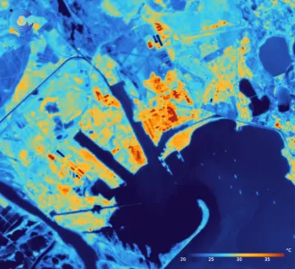
HiVE microsatellites deliver insights never seen before
Our state-of-the-art microsatellite constellation, the High-Precision Versatile Ecosphere (HiVE) monitoring mission, measures absolute surface temperature with unprecedented accuracy at 30m native resolution, providing near-real-time temperature mapping across the planet. If it’s visible from space – be it snow, crops, rooftops, or forest canopies – we can track its temperature. The comprehensive thermal intelligence we record acts as both a real-time data source and a continuously updated input for calibrating broader data environments.
Constellr Belgium is a leading provider of high-resolution thermal infrared (TIR) and visible-near infrared (VNIR) data, specialising in land surface temperature (LST) monitoring for critical applications. The company focuses on near-real-time data processing and dissemination, delivering highly accurate thermal insights for agriculture, water management, infrastructure monitoring and civil security.
Rue des Chasseurs Ardennais 6
4031 Angleur
Belgique